
บักเคิลเบรี
คู่มือท่องเที่ยว


เที่ยว บักเคิลเบรี

pentahotel Reading
Oxford Road Reading England
ขอเงินคืนได้เต็มจำนวน
ราคา ฿2,955 ต่อคืน เข้าพัก 31 ก.ค. ถึง 1 ส.ค.
฿2,955
ราคารวม ฿3,546
31 ก.ค. - 1 ส.ค.
รวมภาษีและค่าธรรมเนียม
เมื่อเดินทางไป เรดดิ้ง แล้วเข้าพักที�่โรงแรมสำหรับครอบครัว แห่งนี้ คุณจะได้เพลิดเพลินกับสิ่งอำนวยความสะดวก/ไฮไลท์ เช่น Wi-Fi ฟรี, อาหารเช้า และ รูมเซอร์วิส 24 ...
8.4/10 ดีมาก! (1,011 รีวิว)
"A below average and disappointing stay. Bed sheets not put on beds properly meaning mattress exposed. Toilet absolutely filthy dirty - no excuse. Felt like a hotel that was probably quite nice 10 years ago but has lost its way. Wouldn't return."
รีวิวเมื่อ 8 ก.ค. 2026

วิลเลจ โรงแรม บราคเนลล์
Bagshot Road Bracknell England
ราคา ฿2,197 ต่อคืน เข้าพัก 2 ส.ค. ถึง 3 ส.ค.
฿2,197
ราคารวม ฿2,637
2 ส.ค. - 3 ส.ค.
รวมภาษีและค่าธรรมเนียม
เมื่อเดินทางไป แบร็คเนลล์ แล้วเข้าพักที่โรงแรมแห่งนี้ คุณจะได้เพลิดเพลินกับสิ่งอำนวยความสะดวก/ไฮไลท์ เช่น Wi-Fi ฟรี, อาหารเช้า และ ซาวน่า ผู้เข้าพักที่จองกับเรารีวิวว่าชอบพนักงานเป็นพิเศษ ...
7.8/10 ดี! (859 รีวิว)
"Very pleasant stay plenty of parking space"
รีวิวเมื่อ 9 ก.ค. 2026

โรงแรม โอริดา โฮเทลส์ นิวบิวรี
M4 Junction 13 Oxford Road Newbury England
ราคา ฿2,210 ต่อคืน เข้าพัก 12 ก.ค. ถึง 13 ก.ค.
฿2,210
ราคารวม ฿2,652
12 ก.ค. - 13 ก.ค.
รวมภาษีและค่าธรรมเนียม
เมื่อเดินทางไป นิวเบอรี แล้วเข้าพักที่โรงแรมธุรกิจ แห่งนี้ คุณจะได้เพลิดเพลินกับสิ่งอำนวยความสะดวก/ไฮไลท์ เช่น Wi-Fi ฟรี, อาหารเช้า และ รูมเซอร์วิส 24 ชั่วโมง ...
7.8/10 ดี! (1,008 รีวิว)
"Decent air conned room bit of paint needed in bathroom nice shower good beds great TV but not a smart TV"
รีวิวเมื่อ 6 ก.ค. 2026
ราคาต่อคืนที่ถูกที่สุดที่พบใน 24 ชั่วโมงที่ผ่านมา อ้างอิงจากการเข้าพัก 1 คืน ผู้เข้าพัก 2 คน ราคาและจำนวนห้องพักว่างอาจมีการเปลี่ยนแปลง อาจมีข้อกำหนดเพิ่มเติม

PREMIER SUITES Reading
Minster Court Reading England
เมื่อเดินทางไป เรดดิ้ง แล้วเข้าพักที่เ��ซอร์วิสอพาร์ตเมนต์แห่งนี้ คุณจะได้เพลิดเพลินกับสิ่งอำนวยความสะดวก/ไฮไลท์ เช่น Wi-Fi ฟรี, จักรยานฟรี และ ที่จอดรถในที่พัก ...
8.8/10 ดีเลิศ! (167 รีวิว)
"Appartement tres bien situe en centre ville"
รีวิวเมื่อ 16 พ.ค. 2026

Central Gate Apartments by House of Fisher
41 West Street Newbury England
เมื่อเดินทางไป นิวเบอรี แล้วเข้าพักที่อพาร์ตเมนต์แห่งนี้ คุณจะได้เพลิดเพลินกับสิ่งอำนวยความสะดวก/ไฮไลท์ เช่น Wi-Fi ฟรี, ที่จอดรถในที่พัก และ ห้องซักรีด ที่เที่ยวยอดนิยมในบริเวณใกล้เคียง ...
9.4/10 ไร้ที่ติ! (74 รีวิว)
"Location, location, location. Right close to shopping, wonderful things to do, especially the Monument Pub! Elevator is nice for luggage."
รีวิวเมื่อ 24 มิ.ย. 2026

Central House by House of Fisher
75-79 Park Street Camberley England
เมื่อเดินทางไป แคมเบอร์ลีย์ แล้วเข้าพักที่อพาร์ตเมนต์แห่งนี้ คุณจะได้เพลิดเพลินกับสิ่งอำนวยความสะดวก/ไฮไลท์ เช่น Wi-Fi ฟรี, ที่จอดรถในที่พัก และ ห้องซักรีด ที่เที่ยวยอดนิยมในบริเวณใกล้เคียง ...
8.2/10 ดีมาก! (90 รีวิว)
"Very good serviced apartments, very central with good parking"
รีวิวเมื่อ 15 พ.ค. 2026
ราคาต่อคืนที่ถูกที่สุดที่พบใน 24 ชั่วโมงที่ผ่านมา อ้างอิงจากการเข้าพัก 1 คืน ผู้เข้าพัก 2 คน ราคาและจำนวนห้องพักว่างอาจมีการเปลี่ยนแปลง อาจมีข้อกำหนดเพิ่มเติม
ที่พักใกล้สถานที่ท่องเที่ยวยอดนิยมใน บักเคิลเบรี
กิจกรรม
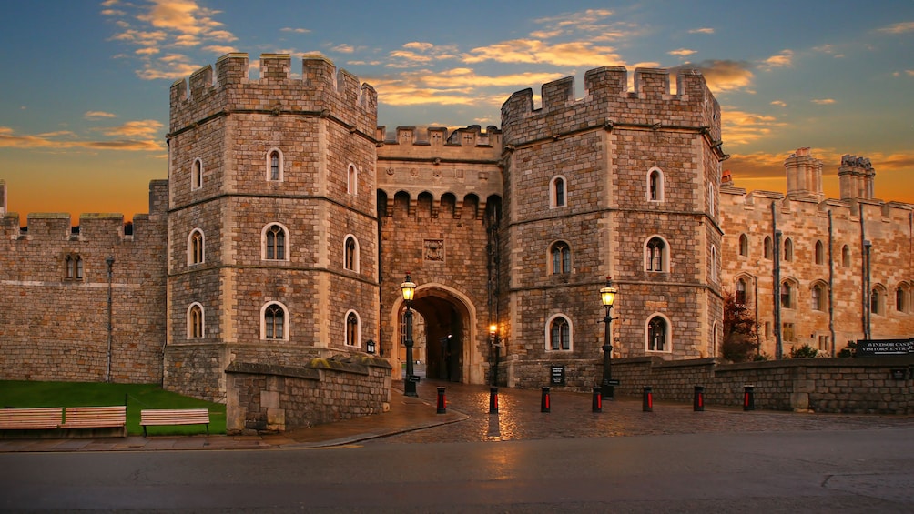
ตั๋วเข้าชมปราสาทวินด์เซอร์
฿1,400
ต่อผู้ใหญ่ 1 คน
82% ของนักเดินทางแนะนำกิจกรรมนี้

จากไบรตัน: เที่ยวอ็อกซ์ฟอร์ด วินด์เซอร์ และอีตันเต็มวัน
฿3,030
ต่อผู้ใหญ่ 1 คน

Legoland® Windsor พร้อมบริการรถรับส่ง
฿3,676
ต่อผู้ใหญ่ 1 คน
74% ของนักเดินทางแนะนำกิจกรรมนี้


